|
|
 |
|
|
Flight Around Denali
Denali National Park, Alaska |
|
|
|
|
|
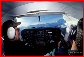
August 31, 2000. The pilot, Greg LaHaie, called it a "2 percent day." I asked what he meant and he said they only get one or two days in a
flying season each year that are that clear. We took off from the little airstrip near Kantishna and headed south. You can see Denali (on the right) and the Alaska Range through the windshield. |
|
|
|
|
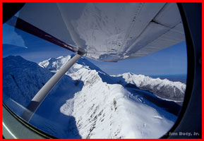
Pioneer Ridge is the brightly lit ridge just below the wing which leads to the North Summit of Denali. Carpe Ridge and Mt. Carpe are to the left.
Muldrow Glacier is in between the two ridges. You are looking southwest. |
|
|
|
|
|
|
|
|
|
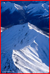
We flew around Denali in a clockwise direction. The Denali massif is surrounded by a number of ridges, buttresses, glaciers, and many other
peaks both large and small. The photo to the left is looking east from just west of Mt. McGonagall. The valley in the dark is Cache creek. You can see another angle in the photo on page 84 of
Mount McKinley, The Conquest of Denali by Bradford Washburn and David Roberts.
|
|
|
|
 |
|
|
|
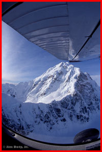
Mount Hunter (to the left) is one of the major peaks just south of Denali. We flew between the two peaks. The pilot, at my request, tipped
the wing up just enough to clear the summit for this photo. There is an interesting comparison photo of Mount Hunter, taken from the summit of Denali, by Bradford Washburn on July 10, 1951. You can find this
photo in Mount McKinley, The Conquest of Denali by Washburn and David
Roberts on page 132. If you are intrigued by Denali, you should read this book. |
|
|
|
|
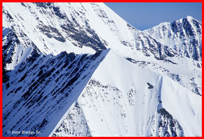
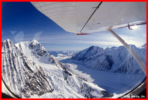
The photos to the right was taken on the south side of the mountain. We are over the upper Ruth Glacier (not visible in this photo) looking at
the ridges that span up to form the South Buttress. We are just north of Mt. Dan Beard. |
|
|
|
|
|
|
|
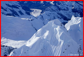
The photo to the left was taken near the Mountain House (Don Sheldon built) on the Ruth Glacier looking south. This is just east of what the
maps call the Rooster Comb. The distant glacier is the Tokisitna. It was a gorgeous day to fly and the scenery was stunning. If you are in the area and have an opportunity to fly around Denali, don't
miss it! |
|
|